Quantcast
Channel: Lake Calhoun – Minneapolis Park History
Viewing all 20 articles
Browse latest View live

Lake Calhoun Bath House and Calhoun Beach Club: From “Disfigurement” to National Register

$
0
0

Charles Loring was the first to sound the alarm about businesses across Lake Street from the Lake Calhoun Bath House, but no one put the criticism so bluntly as Theodore Wirth.

The Calhoun Beach Club loomed over the beach and lake in 1940. The old three-level diving platform was a bit less timid than today's rafts. (Minneapolis Tribune, Minnesota Historical Society)

Four days after the official dedication of the new bath house — with changing rooms, lockers and showers, not to mention $10,000 worth of sand on the new beach — Loring appeared in person at the August 5, 1912 meeting of the Board of Park Commissioners, a board he had once presided over, to plead for the park board to acquire the land across Lake Street from the beach before it became filled with “refreshment stands.” He wasn’t proposing a massive acquisition: the park board already owned Dean Parkway to the west and much of the land between Calhoun and Lake of the Isles to the east. Loring only wanted the board to buy the strip between Lake Street and the railroad tracks sandwiched between existing park lands.

It didn’t. Which gave rise to one of the most novel criticisms ever of a Minneapolis landscape. From one of the most unusual locations.

Writing from a ship sailing from Capetown, South Africa to the Canary Islands in 1936, Theodore Wirth wrote this about Durban, a South African city on the Indian Ocean (see Letters from Theodore post):

Modern Durban. The buildings might still be "monster rent barracks," to use Wirth's phrase, but the atmosphere at Durban's beach has changed much more since 1936 than at Lake Calhoun. This photo looks nothing like what I remember from a visit in 1980.

Along the city side of the Durban Bay is the Marine Parade or Ocean Beach, flanked by a number of imposing modern buildings serving apartment and hotel purposes. The latter are called “flats” here and some of them are deserving of no better name, for they are anything but attractive. I am inclined to classify them as “monster rent barracks” — a still worse disfigurement of an otherwise attractive landscape than our Calhoun Beach Hotel at Dean Boulevard.

Theodore Wirth’s first opinion on the land across from the bath house was expressed in the 1912 annual report when he seconded the words of Loring and then board president Wilbur Decker encouraging the board to acquire the land to preserve it from commercial development.

Their fears may have been prompted by unpleasantness around Minnehaha Park in the  early 1900s. Saloons and other commercial establishments near the falls had contributed to an objectionable environment in the park. In the 1905 annual report of the park board, president Fred Smith wrote that a new pavilion, changes in policing and support from the city administration had “done much to redeem Minnehaha from its unsavory reputation and make it a place where women and children can visit and enjoy their picnics without fear of molestation or insult.”

I can imagine that specter haunting Loring in particular, a man who had run for mayor of Minneapolis in 1882 on a strong anti-saloon platform. Loring also deserved most of the credit for the park board acquiring Minnehaha Falls, Lake Calhoun and Lake Harriet, the three jewels in the park crown at the time, and I’m sure he took a proprietary interest in their well-being, which would not have included “refreshment stands” nearby.

Despite their fears, the land across Lake Street from the immensely popular bath house — it was called the best beach between the oceans — was not filled with houses of debauchery. At least that’s the inference we can draw from another round of encouragement for the park board to acquire the land in 1917. Still it didn’t happen.

Another ten years passed before grand plans for the property took shape. It would become a residential building fitted with its own entertainment and recreation facilities. Curiously, the last mention of the development in park board proceedings is Wirth’s recommendation on April 20, 1927 that the board consent to a building permit for the facility as long as the building did not come within 15 feet of park property along Dean Parkway. The board agreed. Perhaps plans for the property were too far along for Wirth and the park board to fight, or they had no real alternative after taking no action themselves for 15 years

But perhaps Wirth’s objection in 1936 was not that the building was there, but that it was unfinished. Although construction began in 1927 the building remained unfinished and empty until 1946. In a bit of irony, the property Wirth worried would fall into private hands and the building which he said “disfigured” the lake was the site of a tribute dinner to him in 1946 before he moved from Minneapolis to San Diego for health reasons.

The Calhoun Beach Club was added to the National Register of Historic Places in 2003 for its architecture and engineering. The building now adjacent to the commercial and residential “club” was the focus of a fight in 1988 to limit the height of buildings around Minneapolis lakes. That battle resulted in a city ordinance that limits the height of such buildings. When the Calhoun Beach Club was first designed in 1927, at ten stories, it was the tallest building in the city outside of downtown.

David C. Smith   minneapolisparkhistory[at]q.com


Filed under: Lake Calhoun, Minneapolis Parks: General Tagged: Charles M. Loring, Lake Calhoun, Theodore Wirth

Letters from Theodore Wirth: Gardener Above All?

$
0
0

The letters Theodore Wirth wrote to his friends during his 1936 around-the-world voyage, which included a quote on the Calhoun Beach Club, reveal little about Minneapolis parks, but quite a bit about the man.

When Wirth retired as Minneapolis park superintendent in 1935 — he was forced to retire due to civil service age rules — he travelled with his wife to Hawaii, Samoa — where he visited his son, a U. S. Navy officer — Fiji, New Zealand, Australia, South Africa, the Canary Islands, England and on to his boyhood home in Switzerland. Over the course of his travels he wrote ten “general letters” to his friends in Minneapolis. The first was dated December 15, 1935 from a ship sailing from Los Angeles to Honolulu and the last was dated September, 1936 from Winterthur, Switzerland, his home town.

As Wirth explained in General Letter No. 2:

There are so many of you back home that it is of course impossible for me to write to you all. Even if I could do so, it would mean that I would be writing on the same subject time and again. I bargained for a good solution of this problem with Mr. Bossen (his successor as park superintendent) and Miss Merkert (his secretary for many years) before we left home, and I am to write a general letter from time to time, which is to be typed and circulated as may be deemed advisable.

The very method of distributing his letters speaks to his Swiss efficiency, but the content of those letters reveals a good bit about the man as well. Most of his letters are inconsequential newsy travelogues, but I am struck that he was most passionate and enthusiastic about plants on many stops during his voyage.

From his first letter, when he wrote of visiting John McLaren, the famous superintendent of San Francisco parks, he singled out trees for comment. Of California’s Redwood State Park, which McLaren took him to visit, he wrote, “the big Redwood trees are worth a world’s trip to see.” It is the first of many references to the grand and unusual plant life he observed.

Of course he wrote also of parks, commenting on a new park being built in Honolulu, and city planning, noting that Adelaide, Australia was the best-planned city he’d ever seen or heard of. But many of his most detailed observations were about plants.

In New Zealand he makes note of the “elaborately planted” grounds at Lake Rotorua, the “gorgeous tree ferns” towering 50 feet above the undergrowth, even the high yields of New Zealand’s wheat farms.

Of a tour of Sydney’s botanical garden with the curator, he notes a fine specimen of Morton Bay Fig, Ficus Macrophylia with a crown 110 feet in diameter and begonias eight to ten feet tall, concluding “there is no end to what I could report along the lines of plant life here.” He writes that Sydney has much more land set aside for recreation and open space than Minneapolis — Australians are “enthusiastic devotees or every worth while sport” — but it is “sadly lacking” in street tree plantings.

Melbourne is “lavishly decorated with floral displays,” he writes, but he also recounts his travel to see gigantic gum (Eucalyptus) trees six to eight feet in diameter and 150 tall, a “truly majestic sight, not unlike our glorious Redwoods,” and notes that the tuberous begonias at the Fitzgerald Gardens there were the largest he had ever seen.

He writes with special enthusiasm about the bulb nurseries of Holland and how the bulbs were auctioned, mentioning that he had letters of introduction to three bulb-growers from his friend O. J. Olson, a St. Paul florist. He encouraged every florist to visit Holland in May.

Thank you, Sonia Abramson
Copies of the ten letters, 48 pages, Wirth sent to his friends were given to the park board in August 2011 by Ed Abramson. Ed’s aunt, Sonia Abramson, was an employee of the park board, working most of her life in administration. Sonia must have been among those who received copies of the letters after Miss Merkert typed them from Theodore Wirth’s handwritten originals. Ed and his sister-in-law, Cookie Abramson, discovered the letters after his aunt died in 1998 at age 93. Ed recalls that his aunt “loved doing what she did.” “She did a marvelous job for the city and the park board treated her well. It was a win-win,” he said.

Wirth makes two other references to things Minneapolis in his letters — in addition to his Calhoun Beach Club reference.

He provides this account of Pago Pago: “The Pago Pago harbor is not any larger than Lake Calhoun. Imagine the lake surrounded by abruptly-raising, densely wooded mountains from 1,700 to 2,200 feet high — absolutely landlocked — the entrance from the ocean not visible once you are in the harbor.”

He also notes that while sailing from Samoa to Fiji, one morning on deck he was “agreeably surprised” to run into Edward C. Gale, a prominent Minneapolis attorney, son of Samuel Gale and son-in-law of John Pillsbury. They travelled on the same ship until they reached Auckland, New Zealand.

Wirth’s ten letters conclude with a description of parks and playgrounds in Switzerland which suggests where Wirth’s views of parks originated. Among his observations:

“The forests of Switzerland are both the nation’s park and playground in the fullest sense of the word.”
“People flock to the woods singly and in droves to find their recreation.”
“The Swiss people are an exceedingly nature-loving nation — the natural scenic beauty of their homeland makes them so.”
“Playgrounds, as we so properly advocate, build and maintain in the States, are not as essential here in Switzerland.”
“The entire population is more or less self-taught in their practice of exercising, physical culture and body development.”
“Playground activities are managed by the school authorities.”
“Park construction and operation are better known here under the name of “Gardenbau” and the branch of government that has jurisdiction over all pertaining to it is the one of Horticulture.”

These claims tend to corroborate my  impression that Wirth never quite understood the American affinity for organized ball games and competitive sports. While many, many neighborhood playgrounds were designed by Wirth, there was nearly always in his layouts a clash between his instinct to create gardens — at least visually pleasing spaces — and his recognition of the popular demand for playing fields.

Theodore Wirth accomplished many things as a park superintendent, but I believe, as these letters suggest, his first love was gardening and horticulture.

David C. Smith   minneapolisparkhistory[at]q.com


Filed under: Lake Calhoun, Minneapolis Parks: General Tagged: Theodore Wirth

City Ordinance Restricts Building Height Around Minneapolis Lakes

$
0
0

If you’re a long-time follower of Minneapolis politics, you might think this headline came from the 1988 fight to prevent a high-rise building from being constructed next to the Calhoun Beach Club facing Lake Calhoun. But you have to go back much farther in history to get to the first city ordinance to restrict construction on parkways encircling Minneapolis lakes.

I wrote a few weeks ago about Theodore Wirth’s description of the Calhoun Beach Club as a “disfigurement.” In that post I noted that Charles Loring was the first to warn the park board of the likelihood of commercial encroachment on the lake following the highly successful opening of the Lake Calhoun Bath House in July, 1912. Loring urged the park board to acquire the property across Lake Street from the bath house to prevent commercial development there. The fear, I’m sure, was the opening of saloons or dance halls. (Just two years earlier, in June 1910, the park board expanded Riverside Park when a dance hall was planned for land facing the park. The board preempted the dance hall plans by acquiring the land through condemnation.)

Since I wrote that post I’ve learned that by the time Loring made his suggestion in August 1912, the city had already passed an ordinance limiting construction on parkways around the lakes. And it had nothing to do with the Lake Calhoun Bath House. The purpose of the ordinance was essentially to facilitate the construction of this castle.

Gates’ mansion on Lake of the Isles, built in 1913, demolished in 1933. (Minnesota Historical Society)

This is the house built by Charles Gates at 2501 East Lake of the Isles Boulevard in 1913. At 38,000 square feet it is reputed to be the largest mansion ever built in Minneapolis. It stood for less than 20 years.

Of course, such an enormous building requires a good bit of land — and that was the sticking point. As early as May 11, 1912 the New York Times reported that Gates, a New York native, had purchased two blocks of land facing Lake of the Isles for $75,000 and planned to spend another $100,000 building his home there after marrying a Minneapolis native, Florence Hopwood. “The Gates deal is regarded as the most important in residence property ever negotiated in Minneapolis,” wrote the Times.

But judging by an article in the Minneapolis Tribune, July 2, 1912, about the park board meeting the night before, Gates’ purchase of the land on the lake faced obstacles. This is how the Tribune framed the issue:

“Park commissioners were unanimous in urging the taking of steps to put a stop to what they termed the ‘bluffing’ methods of John Cogan of Lake of the Isles Boulevard, who recently refused to continue negotiations with Charles G. Gates for the sale of his property and announced he was going to make a better deal for the sale of his property for a hotel site.”

Commissioner Thomas Voegeli, according to the Tribune, said it was “time for the park board to take a positive stand on the class of structures to be erected on boulevards encircling lakes under park board control.” (Two years earlier Voegeli, owner of two popular downtown drug stores, had paid a record sum at the time — nearly $20,000 — for a 150-foot lot in nearby Kenwood at Logan and Douglas, where he built a new home. Minneapolis Tribune Jan. 16, 1910)

The park board promptly took a “positive stand” and passed, unanimously, this resolution, which Commissioner Carl Peterson said was intended to “foil attempts to make capital off park improvements by erecting inappropriate structures”:

In order to protect the shores of its lakes from the encroachment of apartment houses, flats, hotels and garages, (the Park Board does) hereby request the City Council of the City of Minneapolis to pass an ordinance prohibiting the issuance of a building permit for the erection of any building, except a single dwelling house of not more than three full stories, on any lot facing or abutting on any parkway encircling Lake Harriet, Lake Calhoun, Lake of the Isles or any other lake within the city.

The City Council unanimously passed an ordinance to that effect and it was signed by Mayor J. C. Haynes before the month ended (Proceedings, Minneapolis City Council, July 26, 1912).

I don’t know how or when that ordinance was repealed or amended to permit the construction of the Calhoun Beach Club 15 years later — or many other buildings facing Minneapolis parks that exceed “three full stories.” If anyone knows that story, or where to find more info, send us a note.

The park board’s role in the story of the Gates mansion is a footnote at best, but it played a much bigger part in the stories of two other Minneapolis mansions.

Swan Turnblad and the American Swedish Institute

Swan Turnblad, the publisher of a Swedish language newspaper, built his castle on Park Avenue.

Swan Turnblad’s home, now the American Swedish Institute, on Park Avenue. (City of Parks, Minnesota Historical Society)

He had originally planned to build it on land he owned on the southwest corner of Loring Park. When the park board learned of his elaborate building plans in 1901, which would have made it impossible for the park board ever to add that coveted land to the park, it initiated condemnation proceedings for the land. Turnblad then built his house on Park Avenue. It later became the home of the American Swedish Institute.

William Washburn and Fair Oaks

The home of William Washburn, Fair Oaks, at Stevens Avenue and East 22nd Street, was acquired by the park board in 1915. Washburn sold his 8-acre estate across from what is now the Minneapolis Institute of Arts in 1911 for the cost of the land alone, or $250,000. His home, Fair Oaks, and other buildings were valued at another $400,000. The deal was reached following the donation of Dorilus Morrison’s estate, immediately south of Fair Oaks, to the park board to serve as the future home of the Institute of Arts.

Girls Liberty League activities at Fair Oaks, ca. 1917. (City of Parks, Minnesota Historical Society)

The Washburns’ agreement with the park board allowed them to retain possession of the house for the rest of their lives. The park board assumed control of the property when Mrs. Washburn died in 1915. The park board allowed civic groups to use the home for activities and considered creating park board headquarters in the mansion, but ultimately maintenance of the house proved too expensive for the park board and it was demolished in 1924.

David C. Smith  minneapolisparkhistory[at]q.com

© David C. Smith


Filed under: Lake Calhoun, Lake of the Isles, Minneapolis Parks: General Tagged: Gates Mansion, Lake Calhoun, Lake of the Isles, Loring Park, Washburn Fair Oaks

Canoe Jam on the Chain of Lakes

$
0
0

The newspaper headline hinted of a sordid affair: “Long Line Waits Grimly in Courthouse Corridor.” Many were so young they should have been in school. Others had skipped work. They stood anxiously in the dim hallway, waiting. News accounts put their numbers at 500 when the clock struck 8:30 that April morning. Many had already been there for hours by then. They prayed they would be among the lucky ones to get permits to store their canoes at the most popular park board docks and on the lower levels of the lakeside canoe racks, so they wouldn’t have to hoist their dripping canoes overhead.

The year was 1912 and nearly 2,000 spaces were available on park board canoe racks and dock slips at Lake of the Isles, Lake Calhoun and Lake Harriet. Nearly all of them were needed, which represented a huge increase over the 200 permits issued only two years earlier. The city was canoe crazed.

By contrast, in 2011 the park board rented 485 spaces in canoe racks at all Minneapolis lakes, in addition to 368 sail boat buoys at Calhoun, Harriet and Nokomis.

Canoeing was extremely popular on city lakes, especially after Lake of the Isles and Lake Calhoun were linked by a canal in 1911, followed by a link to Cedar Lake in 1913. (Minnesota Historical Society)

The demand for canoe racks was so great that park superintendent Theodore Wirth proposed a dramatic change at Lake Harriet at the end of 1912 to accommodate canoeists.

Wirth’s plan (above),  presented in the 1912 annual report, would have created a five-acre peninsula in Lake Harriet near Beard Plaisance to accommodate a boat house that would hold 864 canoes. The boat house would have been filled with racks for private canoes, as well as lockers for canoeists to store paddles and gear. The boat house, in Wirth’s words, “would protect the boat owners’ property, and would relieve the shores of the unsightly, vari-colored canoes.”

The board never seriously considered building the boat house and that summer the number of watercraft on Lake Harriet reached 800 canoes and 192 rowboats. Most of the rowboats and about 100 of the canoes were owned and rented out by the park board. Even more crowded conditions prevailed at smaller Lake of the Isles where the park board did not rent watercraft, but issued permits for 475 private canoes and 121 private rowboats.

Rental canoes were piled up on the docks near the pavilion at Lake Harriet ca. 1912. (Minnesota Historical Society)

The park board’s challenge with so many watercraft wasn’t just how to store them, but how to keep order on the lake. An effort to maintain decorum on city lakes began in April 1913 when another year of permits was issued. The park board announced before permits went on sale that because of “considerable agitation about objectionable names” on boats and canoes the year before, permits would not be issued to canoes that bore offensive names.

The previous summer newspapers reported that commissioners had condemned naughty names such as, “Thehelusa,” “Damfino,” “Ilgetu,” “Skwizmtyt,” “Ildaryoo,” “O-U-Q-T,” “What the?,” “Joy Tub,” “Cupid’s Nest,” and “I’d Like to Try It.” The commissioners decided then that such salacious names would not be permitted the next year, even though Theodore Wirth urged the board to take the offending canoes off the water immediately.

When the naming rules were announced the next spring, park board secretary J. A. Ridgway was given absolute power to decide whether a name was acceptable. To begin with he allowed only monograms or proper names, but used his discretion to ban names such as “Yum-Yum” even though that was the name of a character in Gilbert and Sullivan’s “The Mikado.” Even proper names could be improper.

Despite the strict naming rules, all but 75 of the park board’s 1400 canoe rack spaces were sold by late April, and practically all remaining spaces were “uppers” scattered around the three lakes.

The crackdown on canoe-naming wasn’t the end of the park board protecting the morals of the city’s youth on the water however. Take a close look at the 1914 photo below by Charles Hibbard from the Minnesota Historical Society’s collection.

The photo shows canoeists listening to a summer concert at the Lake Harriet Pavilion. Notice the width of the typical canoe and how two people could sit cozily side-by-side in the middle of the canoe. Now imagine how easy it would be to drift into the dark, get tangled up with the person next to you and make the canoe a bit tippy. Clearly a safety issue.

The Morning Tribune announced June 28, 1913 that the park board would have no more of such behavior. “The park board decided yesterday afternoon, ” the paper reported, “that misconduct in canoes has become so grave and flagrant that it threatens to throw a shadow upon the lakes as recreation resorts and to bring shame upon the city.”

The solution? A new park ordinance required people of opposite sex over the age of 10 occupying the same section of a canoe to sit facing each other. No more of this side-by-side stuff, sometimes recumbent. According to the paper, park commissioners said the situation had become one of “serious peril to the morals of young people.” Park police were given motorized canoes and flashlights to seek and apprehend offenders.

The need for flashlights became evident after seeing the park police report in the park board’s 1913 annual report. Sergeant-in-Command C. S. Barnard, referring to the ordinance that parks close at midnight, noted a policing success for the year. To get canoeists off the lake by midnight, the police installed a red light on the Lake Harriet boat house that was turned on to alert lake lovers that it was near 11:30 pm, the time canoes had to leave the lake. Barnard reported that the red light “has been a great help in getting canoeists off the lake by 11:30 p.m., but owing to the large number who stay out past that time (emphasis added), I would suggest that the hour be changed to 11 o’clock in order to enable the parks to be cleared by 12 o’clock.”

Indignant protest against the side-by-side seating ban arose immediately. Arthur T. Conley, attorney for the Lake Harriet Canoe Club, suggested that the park board show a little initiative and arrest those whose conduct was immoral rather than cast a slur on “every woman or girl who enters a canoe.” If Conley believed the ordinance was a slur on men and boys as well he didn’t say so, but he did add, “We dislike to hear that we are engaged in a sport which is compared with an immoral occupation and that we are on the lake for immoral purposes.”

In the face of protests, the new ordinance was not vigorously enforced and was repealed before the start of the 1914 canoe season. The Tribune noted in announcing the repeal that “the public did not take kindly to the ordinance last year and boat receipts at Lake Harriet fell off considerably on account of it.”

Despite the repeal of the unpopular ordinance, boating fell off even more in 1914. In the annual report at the close of the year Wirth attributed the decline partly to a terrible storm that passed over Lake Harriet on June 23 resulting in the drowning of three canoeists. Newspapers reported dramatic rescues of several others. By 1915 the number of canoe permits had dropped under 1400 even though canoe racks had been added to Cedar Lake, Glenwood (Wirth) Lake and Camden Pond.

The popularity of canoeing continued to decline. Wirth noted in 1917 that there had been a very perceptible decrease again in the number of private boats and canoes on the lakes. While he attributed that decline partly to unfavorable weather, he also noted the “large number of young men drawn from civil life and occupations to military service” as the United States entered WWI.

There were only six sail boats on city lakes in 1917, and all six were kept on Lake Calhoun. The first year that the park board derived more revenue from renting buoys for sail boats than racks for canoes was not until 1940. From then until now sailing has generated more revenue for the park board than canoeing.

The number of canoe permits leveled off for a while in the 1920s at about 1000 per year, but the canoe craze on the lakes had passed, much as the bicycle craze of the 1890s. During the bicycle craze the park board had built a corral where people could check their bikes while at Lake Harriet. That corral held 800 bicycles. At the peak of the much shorter-lived canoe craze in the 1910s, the park board provided rack space at Lake Harriet for 800 canoes. Popular number. Fortunately, the park board did not build permanent facilities — or a peninsula into Lake Harriet — to accommodate a passing fad.

David C. Smith   minneapolisparkhistory[at]q.com

© David C. Smith


Filed under: Lake Calhoun, Lake Harriet, Lake of the Isles, Minneapolis Parks: General Tagged: Canoeing, Lake Calhoun, Lake Harriet, Lake Harriet Pavilion, Lake of the Isles, Theodore Wirth

1955 Was a Very Dry Year

$
0
0

It’s not a common sight. I’d never seen it myself until I saw this picture from Fairchild Aerial Surveys taken in 1955. St. Anthony Falls is completely dry.

The concrete apron at St. Anthony Falls is bone dry in 1955. The 3rd Avenue Bridge crosses the photo. Dry land — even a small structure — left (west) of the falls stand where the entrance to the lock is now. (Fairchild Aerial Surveys, Minneapolis Park and Recreation Board)

Water levels were down everywhere at the time. Meteorological charts list 1955 as the 13th driest year on record in Minneapolis, but a look at longer-term data reveal that rainfall had been below normal for most of the previous 40 years. Downstream from St. Anthony Falls, the river was also very low, revealing the former structure of the locks at the Meeker Island Dam.

The old lock structure from the Meeker Island Dam protrudes from the low water in 1955. The old lock and dam between Franklin Avenue and Lake Street were destroyed when the new “high dam” or Ford dam was built near the mouth of Minnehaha Creek downriver. (Fairchild Aerial Surveys, Minneapolis Park and Recreation Board)

That dry spell had a significant impact on park property. Many park board facilities, from beach houses to boat houses and docks, were permanent structures that required proximity to the water’s edge. Parks were also landscaped and mowed to the water line and, since the depression, at least, many lakes had WPA-built shore walls that looked goofy a few feet up on dry land.

Park board annual reports provide time-lapse updates.

1948: Minnehaha Creek dry most of the year, lakes down 1.5 feet.

1949: Chain of Lakes 2 feet below normal, rainfall 2.5 inches below normal, water in Minnehaha for limited time during year

1950: Lake levels at record lows, lake channels dredged 4.5 feet deeper to allow continued use, water in Minnehaha Creek for only brief period in spring

1951: Record snowfall and heavy rains raised lake levels o.44 feet above normal in April; flooding problems along Minnehaha Creek golf courses required dikes to make courses playable; attendance at Minnehaha Park high all year due to impressive water flow over falls.

1952: Wet early in year, dry late; lake levels stable except those that depend on groundwater runoff, such as Loring Pond and Powderhorn Lake, which were down considerably at end of year

1953: Lake levels fluctuated 1.5 feet from early summer to very dry fall; flow in Minnehaha Creek stopped in November; U.S. Geological Survey began testing water flow in Bassett’s Creek for possible diversion

1954: Again, water level fluctuations; near normal in early summer, low in fall; Minnehaha Creek again dry in November.

1955: Fall Chain of Lakes elevation lowest since 1932, but Lake Harriet near historical normal; Minnehaha dry most of year

1956: Lakes 4 feet below normal, weed control required, boat rentals incurred $10,000 loss

1957: City water — purchased at a discount! — pumped into lakes raised lake levels 1.5 feet; park board began construction of $210,000 pipeline from Bassett’s Creek, which, unlike Minnehaha Creek, had never been completely dry, to Brownie Lake.

1958: Second driest year on record; Minnehaha Creek dry second half of year; pumps activated on pipeline from Bassett’s Creek, raised water level in lakes 4.2 inches by pumping 84,000,000 gallons of water.

1959: Dry weather continued; Park board suggested reduction in water table may be result of development; Park board won a lawsuit against Minikahda Club for pumping water from Lake Calhoun to water golf course. When Minikahda donated lake shore to park board for West Calhoun Parkway in 1908 it retained water rights,  but a judge ruled the club couldn’t exercise those rights unless lake level was at a certain height — higher than the lake was at that time — except in emergencies when it could water the greens only. Lakes were treated with sodium arsenite to prevent weed growth in shallower water; low water permitted park crews to clean exposed shorelines of debris.

1960: Lake levels up 4 feet due to pumping and rain fall; channels between lakes opened for first time in two years; hydrologist Adolph Meyer hired to devise a permanent solution to low water levels.

To celebrate the rise in water levels sufficient to make the channels between the lakes navigable after being closed for a couple of years, park superintendent Howard Moore helped launch a canoe in the channel between Lake of the Isles (in background) and Lake Calhoun in 1960. He seems not to mind that one foot is in the drink. (Minneapolis Park and Recreation Board)

That’s more than a decade’s worth of weather reports. The recommendation of hydrologist Adolph Meyer was very creative: collect and recycle water from the air-conditioners in downtown office buildings and stores, and pump it to the lakes. That seemed like a good idea until the people who ran all those air-conditioners downtown thought about it and realized they could recycle all that water themselves through their own air-conditioners and save a lot of money on water bills. End of good idea. Instead the park board extended its Chain of Lakes pumping pipeline from Bassett’s Creek all the way to the Mississippi River.  But that’s a story for another time.

If you’ve followed the extensive shoreline construction at Lake of the Isles over the last many years, you know that water levels in city lakes remains an important, and costly, issue — and it probably always will be. It’s the price we pay for our city’s water-based beauty.

David C. Smith   minneapolisparkhistory.com

Afterthought: The lowest I ever remember seeing the river was following the collapse of the I-35W bridge. The river was lowered above the Ford Dam to facilitate recovery of wreckage from that tragedy. Following a suggestion from Friends of the Mississippi River, my Dad and I took a few heavy-duty trash bags down to the river bank near the site of the Meeker Island Dam to pick up trash exposed by the lower water levels. Even then the water level wasn’t as low as in the Fairchild photos.


Filed under: Brownie Lake, Lake Calhoun, Lake of the Isles, Minneapolis Parks: General, Mississippi River Tagged: Bassett's Creek, Brownie Lake, Lake Calhoun, Lake of the Isles, Minnehaha Creek, Mississippi River, St.Anthony Falls

The Makwa Club’s Lake Calhoun Toboggan Slide

$
0
0

A couple of months ago I posted photos of a toboggan slide at Lake Harriet in 1914. Now I’ve rediscovered a description I had saved long ago of a toboggan slide from an earlier time on a Minneapolis lake. The Makwa Club — makwa is the Ojibwe word for “bear” — built a toboggan slide at Lake Calhoun in 1888, according to the Minneapolis Tribune, January 22, 1888.

The Tribune reported that the Makwa Club was formed in 1885 and had its first toboggan slide on Lowry Hill near Thomas Lowry’s house. For the winter of 1888 the club built a much grander slide at Lake Calhoun. The Tribune reported, “The slide is much superior to any that has been built in Minneapolis before and is probably as fine as any that is in existence in the country.”

The other toboggan slides in the city that winter were maintained by the Flour City Toboggan and Snowshoe Club and the North Star Toboggan Club. (Newspapers of the time referred often to the toboggan “craze,” much like the bicycle craze that would soon follow, and the canoe craze that came after that. Today, I suppose, we text or tweet.) The Flour City slide was a 1,000-foot slide near Ridgewood Avenue that ended near Franklin and Lyndale. The North Star slide was west of the city in what is now Theodore Wirth Park.

The only photo I can find of a toboggan slide from that era was the North Star chute on Glenwood Hill, 1887. (Minnesota Historical Society)

The Makwa slide was 220-feet long, running onto Lake Calhoun from the bluff on the east side of the lake where the Lyndale Hotel once stood. The slide had three chutes that had a drop of 55 feet and crossed both the street railway track — 15 feet above the track — and Calhoun Parkway — 24 feet above the road. (Yes, the Makwas did get the permission of the park board to build its slide over the parkway.) The slide met the lake ice about 50 feet out from the shore and the level runway continued 1,500 feet onto the lake. After a run of about 1/3 mile, toboggans hit roughed up lake ice that prevented them from running onto Lake Calhoun’s horse trotting track.

The grandest feature of the slide, however, “had never before been tried in any slide,” according to the Tribune: a wooden warming house and starting platform at the top of the slide, 10 feet off the ground. The front of the warming room was made almost entirely of glass and looked straight down the slide,. The slide was illuminated by five electric lights.

The Makwas even had an arrangement with the motor (trolley) company by which the 7:40 train out from town every evening stopped at the foot of the slide to drop off club members and the 9:57 train made a special stop at the same place to pick them up for a return to the city after an evening of mirth. The slide was for the use of club members only.

The Makwa uniform was breeches and blouse of heavy gray French wool and stockings, toque and sash of cardinal. The membership of the club was limited to 200 and included many of the best-known young men of Minneapolis. The president of the club in 1888 was English journalist Harry P. Robinson, who was featured in an earlier article about his close friend John S. Bradstreet. Bradstreet was a Makwa, as was park commissioner Eugene Wilson.

The problem with the Makwa’s grand slide was that no one was willing to pay for it. In 1891, the Tribune reported that a lawsuit had been filed — in what it called the “Makwa mess” — by the man who built the slide in an attempt to recover his costs from the officers of the defunct club. Makwa Club members had been assessed $10 each to pay for the slide in 1888, but most didn’t pay. Some claimed that the officers of the club did not have the authority to spend the money on the slide. (I wonder if these claimants used the slide!) Of the $800 charged to build the slide, only about $300 had been paid. The Makwa directors, including Robinson, then sued individual members who hadn’t paid up. The Tribune reported on only two of those cases: one was not contested and the other lost on a technicality.

One of the “chief forms of pleasure that the belles and bloods of the city indulged in” that winter through “the most select of all the clubs” ended up being a free toboggan ride for most of them. (Tribune, March 20, October 18, December 22, 1891.)

By the fall of 1891, however, Makwa president Robinson had married the daughter of one of the wealthier men in Minneapolis, Thomas Lowry, so he may have found the means to pay the builder of the toboggan slide that was “much superior” to any other in Minneapolis.

If you’ve ever seen a picture of the Makwa Club’s Lake Calhoun toboggan slide, please let us know. We’d love to see it.

David C. Smith   minneapolisparkhistory[at]q.com

© David C. Smith


Filed under: Lake Calhoun, Minneapolis Parks: General, Winter Sports Tagged: Harry Perry Robinson, Lake Calhoun, Makwa Club, toboggan slide

Friday Photo: Lake Calhoun North Shore

$
0
0

One of my favorite photos of Lake Calhoun. The photo is undated, but I would estimate that it was taken in the late 1910s. The view indicates it was taken from the Minikahda Club on the west side of the lake looking northeast toward downtown. The photo was taken after the Lake Calhoun Bath House (center) was completed in 1912, but before a parkway was built on the west side of the lake, which occurred in the early 1920s.

Lake Calhoun's northwest shore and Bath House in late 1910s. Photo taken from Minikahda Club. (Minneapolis Park and Recreation Board)

Lake Calhoun’s northwest shore and Bath House in late 1910s. Photo taken from Minikahda Club. Click to enlarge. (Minneapolis Park and Recreation Board)

Note how far into the lake the diving platforms were built.

One of things I like from this photo is a sense of the connection between Lake of the Isles and Lake Calhoun. There is some open land between them. This was taken a few years before construction began on the Calhoun Beach Club across Lake Street from the bath house.

Another remarkable feature of this photo is the prominence of the Basilica on the skyline west of downtown. The Basilica was dedicated in 1914.

This is the view that Theodore Wirth hoped could one day be incorporated into the park system if the Minikahda Club ever relocated. Wirth wrote in the 1906 Annual Report of the Board of Park Commissioners, his first, that this view was of “such scenic beauty that it is almost a crime to pass it unnoticed.”

David C. Smith   minneapolisparkhistory[at]q.com

© David C. Smith


Filed under: Lake Calhoun, Minneapolis Parks: General Tagged: Lake Calhoun, Lake Calhoun Bath House

Approaching Lake Calhoun

$
0
0

Two photos from the 1950s, and two that are much older, show how people got to Lake Calhoun once upon a time. Both photos are from the Minnesota Historical Society’s online collection. I haven’t written about that collection in some time, but I continue to use it extensively for research on Minneapolis parks and other historical subjects. You should take a look if you haven’t before. It’s a treasure.

The first photo shows the intersection of Lake Street, Dean Parkway and West Calhoun Parkway, looking west.

Many Minneapolis parkways were once called “boulevards”, but that changed in 1968 when the Minneapolis park board renamed nearly all of them “parkways.” The park board wanted to create uniformity in treatment, but also believed that by calling them parkways, people would better understand that they were owned by the park board and were part of the park system. I still refer to them as boulevards at times, out of habit, as do many others. Curiously, Google maps hedges, labelling the road around the west side of Lake Calhoun “W Calhoun Pkwy” and “Calhoun Blvd”.

Travelling west on Lake St. at Dean Parkway. West Calhoun Pakrway begins at far left. (Norton and Peel, Minnesota Historical Society)

Travelling west on Lake St. at Dean Parkway. West Calhoun parkway begins at far left. (Norton and Peel, Minnesota Historical Society)

Note that the lot on the southwest corner of the intersection (upper left) is still undeveloped in 1953.

Aerial view of the American Hardware Mutual Insurance Company building. Excelsior Blvd. is in the foreground. 1956. (Minneapolis Star Journal Tribune, Minnesota Historical Society)

Aerial view, 1956. Excelsior Blvd. is in the foreground.  Minnesota Historical Society)

The earliest photos I’ve found of the American Hardware Mutual Insurance Company building on the site are dated 1956, such as this aerial photo from the Minneapolis Star Journal Tribune.

The park board never owned that piece of land, although it would have been a good addition to the lake park. The park board reported in 1916 that the purchase of 93 acres on that corner was pending, but the deal never was completed. The land behind the building to the southwest was once a small bay of the lake, which the park board filled with material dredged from the lake bottom.

Perhaps it’s simply an issue of the resolution of this photo, but I don’t see traffic lights even though it appears that east- and west-bound  traffic is stopped. The lights must have been installed about this time, because the city engineer had developed an initial plan for lights at this increasingly busy intersection in 1951.

The photo below was taken at the opposite, or southeastern, corner of Lake Calhoun at about the same time.

36th Strret approaching teh southestern corner of Lake Calhoun. 1955. (Norton and Peel, Minnesota Historical Society)

36th Street approaching the southeastern corner of Lake Calhoun, 1955. Lakewood Cemetery is on the left. (Norton and Peel, Minnesota Historical Society)

The photo is notable especially because the foundation of the street railway bridge over 36th Street still stands. This was the location of the rails that went to Lake Harriet and beyond to Excelsior and Lake Minnetonka. Of course, there were no traffic lights at the intersection of 36th and East Calhoun Parkway either.

In this photo of East Calhoun Parkway in about 189, you can see the bridge foundation at the extremeright, where one carriage is turning onto 36th Street. The fountain in the boulevard for watering horses  was an interesting touch.(Minnesota Historical Society)

East Calhoun Parkway in about 1890. Looking nroth from Lakewood Cemetery.(Minnesota Historical Society)

The trestle had been there since before the park board built the parkway. (See more on the Lyndale Railway Company at Lake Calhoun and Lake Harriet.) In the photo at right you can see the bridge foundation (far right), in front of the carriage turning east onto 36th Street. The fountain in the boulevard for watering horses was an interesting touch. So was the scalloped hedge between the parkway and the lake. Does anyone know when the street railway bridge supports were torn down?

Most of the earliest parkways around lakes ran right along the water’s edge. That feature of early parkways is more prominent in the photo below of the end of Calhoun Parkway in about 1905. At that time the parkway ended where it turned south to connect to Lake Harriet. The land behind the photographer in this photo was private land all the way around the west shore of the lake back to Lake Street and the top photo.

The end of Calhoun Parkway at the south end of Lake Calhoun in 1905. The road turned to the right, the future William Berry Parkway, connecting to Lake Harriet. (Minnesota Historical Society)

The end of Calhoun Parkway at the south end of Lake Calhoun in 1905. The road turned to the right, the future William Berry Parkway, connecting to Lake Harriet. (Minnesota Historical Society)

The photo below shows the approach to the north end of Lake Calhoun from about the same time period as the photo above.

The north shore of Lake Calhoun from Lake Street, facing west in about 1902.

The north shore of Lake Calhoun from Lake Street, facing west in about 1902. (Minnesota Historical Society)

This photo shows Lake Street facing west at the northeast corner of Lake Calhoun. This was before the park board acquired the north shore of the lake. The only park land around the lake at this time was Calhoun Parkway beginning at the left of this photo and continuing to the previous photo.

David C. Smith  minneapolisparkhistory[at]q.com


Filed under: Lake Calhoun, Minneapolis Parks: General Tagged: Dean Parkway, Lake Calhoun, William Berry Parkway

Approaching Lake Calhoun — A Couple Years Later

$
0
0

Julieann Swanson, Assistant Curator of Digital Collections and Archives at the University of Minnesota’s College of Design  just sent a fabulous photo of the Lake Street, Dean Parkway, and West Calhoun Parkway intersection from about 1956 in response to my post earlier today. See Julieann’s comments on that post for more information on this photo and the Digital Content Library.

Looking west on Lake Street at the intersection of Dean Parkway and West Calhoun Parkway. (University of Minnesota, Digital Content Library)

Looking west on Lake Street toward the intersection with Dean Parkway and West Calhoun Parkway. (Photo: University of Minnesota, Digital Content Library)

Julieann suggested that the photo is circa 1955, but I’ve advanced it a year to 1956, because I believe that is a red 1956 Chevy sitting at the east-bound stop light. And, yes, the traffic lights are quite visible in this photo! Would that car have been called, “Cherry”? I’m a little too young to remember ’50s slang.

Thanks, Julieann.

David C. Smith   minneapolisparkhistory[at]q.com

© 2013 David C. Smith


Filed under: Lake Calhoun, Minneapolis Parks: General Tagged: Dean Parkway, Lake Calhoun

Lake Harriet: The Heart of the Minneapolis Park System

$
0
0

NOTE: The following outline and photos introduce the important role of Lake Harriet in the creation and growth of the Minneapolis park system. While much of this information is familiar to Minneapolis residents, I prepared this presentation for students visiting Minneapolis today from University of Wisconsin Eau Claire. I thought other readers of minneapolisparkhistory.com might enjoy the images and information as well. For more in-depth info visit the history pages of the Minneapolis Park and Recreation Board. For a more complete picture of the parks surrounding Lake Harriet see the history of Lake Harriet, but also of William Berry Park and Lyndale Park.


If the prized Minneapolis park system were a living thing, Lake Harriet would be its heart. The Grand Rounds — 60 miles of parkways threaded through the city — would be the rest of the circulatory system of veins and arteries. The analogy holds more for the creation of the park system, with parkways radiating out from Lake Harriet and back, than for the current function of Lake Harriet in the system.

Lake Harriet and Lake Calhoun had always been primary targets of people in Minneapolis and St. Anthony who believed the growing towns needed parks. For decades, residents of the small towns beside St. Anthony Falls had taken Sunday excursions to the shores of the lakes for picnics and relaxation. As early as 1869, the Board of Trade, a chamber-of-commerce type organization, had voted to acquire the shores of Lake Calhoun for a “pleasure drive” and had secured commitments from all landowners around the lake except one to donate their shoreline for that purpose. That one unnamed holdout must have torpedoed the entire plan.

When the Minneapolis park board was created by an act of the Minnesota Legislature and ratified by Minneapolis voters in 1883, it was well-understood that the lakes would become part of a new park system. Proof was easy: the legislature expanded the city limits of Minneapolis to include Lake Harriet at the same time it created the park board. One went with the other.

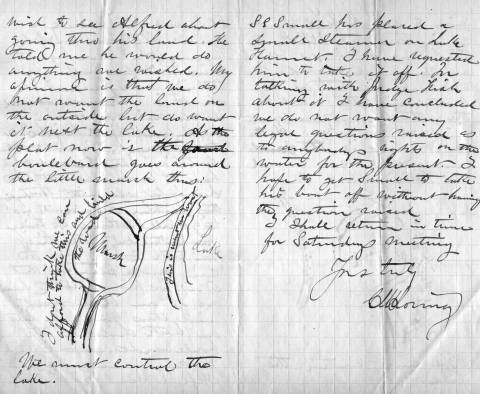
One of the park board’s first acts was to hire landscape architect and park advocate H. W. S. Cleveland to advise the board on the creation of parks. About a month later Cleveland presented his “Suggestions” to the broad for a new park system featuring interconnected parkways rather than just a couple large parks. The map that accompanied his suggestions, below, shows in red the parkways he recommended. Note that only Lake Harriet is fully encircled by parkway, the “heart” of this circulatory system.

Horace Cleveland proposed this system of parks and parkways in 1883. (Minneapolis Park and Recreation Board)

Horace Cleveland proposed this system of parks and parkways in 1883. (Minneapolis Park and Recreation Board)

The map provided a blueprint for a park system that the park board tried to implement. Although the board failed to acquire many of the specific routes proposed by Cleveland — and added others — the concept of a system of parkways encircling the city eventually became the Grand Rounds parkway system of today.

Cleveland used another anatomical metaphor in the park system he proposed that focused on what was most important to him. He called the Mississippi River gorge and parkways on both sides the “lungs” of the city. He meant that a corridor of green on both sides of the river — the “jewel” of the city — would provide a flow of fresh air through the city north to south, which would help prevent pollution and disease.  It was not a coinage that originated with Cleveland, but had been used to advocate city parks in the dense and squalid urban cores of Paris and London since early in the century.

In fact, however, the Grand Rounds parkway system had its start at Lake Harriet and the rest of the parkways followed. It was the first parkway the park board attempted to acquire. A first appraisal of the shores of the lake put the cost at $300,000, much more than the park board could legally spend. Then landowners Henry Beard, Charles Reeve and James Merritt approached park board president Charles Loring with an offer: they would donate to the park board a strip of land 125 feet wide that nearly encircled the lake. The park board gratefully accepted that offer 1985. (Ownership of a portion of that land was being contested at the time in court and a court ruling returned much of the land to William S. King, then a park commissioner. He honored the deal already struck with the other landowners and the park board owned a strip of land for a parkway around most of the lake.)

The park board’s other parkway projects revolved primarily around creating routes from other parts of Minneapolis to Lake Harriet. Hennepin Avenue was acquired to be a parkway connection from Central (Loring) Park to Lake Harriet. But when heavy traffic on that road dimmed its prospects for ever being a parkway, an alternative route to Harriet was found. Land was donated for Kenwood Parkway from Central Park to Lake of the Isles, then around Lake of the Isles, which hadn’t figured at all in Cleveland’s plan, to Lake Calhoun. The park board purchased the eastern shore of Lake Calhoun, at what Loring considered an exorbitant but necessary price, to reach the southern tip of Lake Calhoun. From there, Linden Hills Boulevard, also acquired from Henry Beard, would carry traffic to Lake Harriet.

Cleveland conceived of another major circulatory connection to Lake Harriet as a parkway east from Lake Harriet to the Mississippi River. He envisioned that to be Lake Street, but that thoroughfare already was home to a concentration of businesses that made it too expensive to acquire. The route east from Harriet that later emerged, largely due to free land, was Minnehaha Creek. Although much farther south and far from the central city neighborhoods that Cleveland thought would need a parkway, Minnehaha Parkway became the park connection to Minnehaha Falls and the river parkways.

Even the parkways from the Lake District into north Minneapolis were really arteries directly from the north side to Lake Harriet. When it became evident that Lyndale Avenue could not be converted into a parkway from Central Park north, the park board looked to the west to connect Lake Harriet via Cedar Lake and what eventually became Theodore Wirth Park and Parkway to north Minneapolis. Once again the appeal, at first, was the prospect of free land along that route from William McNair, a friend of the parks and several park commissioners.

Further supporting the Lake Harriet-as-heart metaphor is that the northern half of the Grand Rounds was inspired by what had already occurred in the southern half of the city connecting lakes, river, and creek to Lake Harriet. William Folwell, former University of Minnesota president, park commissioner and Cleveland’s close friend, urged the park board in a special report at the end of 1890 to return to the vision of Cleveland. In his report, he urged the board to resurrect and finish the system of parkways throughout the city that Cleveland had suggested. Folwell even gave that system of parkways, which began and ended at Lake Harriet, a name for the first time: Grand Rounds.

To the Water’s Edge

The parkway at Lake Harriet also established another critical precedent in the history of Minneapolis parks. In keeping with Cleveland’s plan for an interconnected system of parkways, the park board wanted a parkway around the lake instead of just a large park beside it. The parkway acquired encircled the lake on its shoreline. That meant the park board owned the entire lake and it established that precedent for later acquisitions at Lake of Isles, Lake Calhoun, Minnehaha Creek, even the Mississippi River gorge. Nearly everywhere in Minneapolis, the park board owns the water front. The only places that is not true today is the banks of the Mississippi River above the falls, and that is in the process of being acquired piece by piece, and those parts of Bassett’s Creek that had been tunneled below ground even before the park board was created.

The unique and defining feature of Minneapolis today is not only that the city has lakes and creeks and a river running through it, but that almost all land abutting those bodies of water is publicly owned and preserved as parkland.  We aren’t restricted to a glimpse of water between mansions built on lakeshores, the people own the lake shores. The effect on the prosperity of the city has always been significant. As Minneapolis park board studies have shown, property values are increased not only adjacent to the lakes, creeks and river but up to several blocks away from those amenities because they are publicly owned.

Donation of Land

Another reason for the centrality of Lake Harriet to the development of the Minneapolis park system was the means by which the park board acquired the Lake Harriet shoreline: it was donated. That also established a precedent that Charles Loring, in particular, was very successful in replicating. Loring secured other land donations in the few years after the donations by Beard, Reeve, Merritt and King. Kenwood Parkway, most of Lake of the Isles, half of Lake Calhoun, part of Cedar Lake, much of Minnehaha Creek, Stinson Parkway, Lyndale Park and The Parade. Even much of the river gorge was sold to the park board well below market value.

Let Us Entertain You

Lake Harriet was also the heart of park board expansion into new areas, especially providing entertainment and recreation. Entertainment at the lake began at a pavilion built by the street railway company on private land beside  the lake, but became one of the most popular destinations in the city after the park board allowed the street railway company to build a pavilion on the shores of the lake in 1892. The park board didn’t provide the entertainment directly, but did exercise considerable control over the types of entertainment the railway company was allowed to present. That entertainment did not always meet the approval of all park commissioners, but it continued because people liked it and turned out by the thousands. It is one of the first examples of the nature of parks being adapted to what people wanted.

First pavilion built on the Lake Harriet shoreline in 1892. The pavilion ws designed by Harry Wild Jones. (Minnesota Historical Society)

The first pavilion built on the Lake Harriet shoreline in 1892. The pavilion was designed by Harry Wild Jones. This view is from the streetcar station in about 1895. (Minnesota Historical Society.)

Another important attraction at the Lake Harriet Pavilion were row boats. One of the donors of land around the lake Charles Reeve offered in 1887 to pay the park board $1,000 for the right to rent boats and sell refreshments at the lake. Competitive bidding pushed the price up to $1,250, a large sum in the day, before Reeve gained concession rights. But by 1889 the park board realized it could make a nice profit running the boat and refreshment concessions itself and purchase Reeve’s boats.

The park board's boats for rent next to the Lake Harriet pavilion in 1895. (Minnesota Historical Society)

The park board’s boats for rent next to the Lake Harriet pavilion in 1895. (Minnesota Historical Society)


Lake Harriet pavilion and boat dock, 1905

When the first lakeside pavilion burned down, it was replaced by another Harry Wild Jones-designed structure that extended into the lake in 1904. At the new pavilion, musical performances took place on the roof. The bandshell pictured had terrible acoustics and was replaced after one year. The bandstand was moved to the east side of the lake at 46th Street as a lookout. The boat rental business continued to thrive. (Minnesota Historical Society)

View from the bandstand on top of the Lake Harriet Pavlion in 1905. (Minnesota Historical Society)

View from the bandstand on top of the Lake Harriet Pavilion in 1905. Notice how far down the shore the boat dock stretches. A seat on the roof for a concert cost 25 cents. (Minnesota Historical Society)

The crowd attanding a concert on the pavilion roof in 1912. Photographed from the stage. (Charles J. Hibbard, Minnesota Historical Society)

The crowd at a concert on the pavilion roof in 1912, photographed from the stage. (Charles J. Hibbard, Minnesota Historical Society)

The Bicycle Craze

Active recreation, physical exercise, began at Lake Harriet with boating and canoeing, but then along came the bicycle craze of the 1890s and the park board continued what has become a long tradition of accommodating what people wanted from their parks.

Bicycling was so popular that the park board built a bicycle path around the lake in 1896. So many people rode bicycles to the lake that the park board built an enclosure where people could check their bicycles while they were at the pavilion or renting a boat. It was built to hold 800 bicycles. Soon after, the park board built bicycle trails along Minnehaha Creek as well.

This is one of my favorite park photos. It shows bicycle paths around Lake Harriet in 1896. Notice that the layout of walking path, bicycle path and carriage way, there were no cars yet, is almost identical to today. (Minneapolis Park and Recreation Board)

One of my favorite Minneapolis park photos shows the bicycle path around Lake Harriet in 1896. This was the first bicycle path in Minneapolis. The layout of walking path, bicycle path and carriage road is almost identical to today. (Minneapolis Park and Recreation Board)

These are just the beginning of the accommodation of public desires at Lake Harriet and then other park properties. What began at Lake Harriet, like the parkways radiating out from it, quickly extended to other parts of the park system even as new amenities were added at Lake Harriet. From the picnic shelter at Beard Plaisance on the west side of the lake in 1904 to the Rose Garden created on the east side of the lake in 1907, the throngs drawn to the lake were regularly provided new attractions.

David C. Smith   minneapolisparkhistory[at]q.com

© 2014 David C. Smith


Filed under: Lake Calhoun, Lake Harriet, Lyndale Park, Minneapolis Parks: General Tagged: H. W. S. Cleveland, Horace Cleveland, Lake Harriet, Lake Harriet Pavilion, Lyndale Park, William Berry Park

1911 Minneapolis Civic Celebration: Junk Mail

$
0
0

I have neglected these pages in recent months, yet I have so many good park stories to tell, some of them from readers. I will get to them soon I hope. In the last eight months I have discovered more fascinating information about Minneapolis parks and the people who created themthan at any time since my initial research for City of Parks. But until I can get to those stories, I wanted to show you one of the more interesting bits of history I’ve encountered recently. Garish, but oddly charming.

The images below are of a promotional envelope used by a Minneapolis merchant in advance of the July 1911 Civic Celebration that was conceived primarily to celebrate the digging of the channel that connected  Lake Calhoun with Lake of the Isles — as is noted at the bottom of the envelope. I found these images on an Ebay auction site and use them with permission of the seller of the envelope who sells mostly postal history under the name of “gregfree”. This envelope is for sale at an opening bid of $150 — more than I can pay. I appreciate gregfree’s willingness to let me share the image with you. Maybe you should buy it. If you do, thank him for me.

A promotional envelope used by a Minneapolis merchant. One of the objectives of the Civic Celebration was to give businesses an opportunity to contact, perhaps entertain and certainly solicit business from their clients throughout the region.

A promotional envelope used by a Minneapolis merchant. One of the objectives of the Civic Celebration was to give businesses an opportunity to contact, perhaps entertain and certainly solicit business from their clients throughout the region.

I love the background in green, a photo of the Stone Arch Bridge and Mill District, laid over a map of the city that shows the Chain of Lakes and Minnehaha Creek meeting the Mississippi River in the lower right corner.

Teh back of teh envelope is an advertsiemen tfor Minneapolis, and from my perspective the lede is inot buried.

The back of the envelope is an advertisement for Minneapolis, and from my perspective the lede is not buried — “Public Park System Unequalled.” That puts the emphasis exactly where it should be!

It’s nice to know that Minneapolis also had the lowest death rate in the United States. How that was measured, I’m not sure.

The coincidence of me finding this image now has a bit of Ouija-Board spookiness to it, because the lake connections have been on my mind — and in the news — a good bit lately. The channel that was celebrated 103 years ago between Isles and Calhoun has been in the news because the developer of a residential building at Knox Avenue and Lake Street has been pumping millions of gallons of water from a flooded underground parking garage into that channel, which has prevented it from freezing and caused considerable increase in phosphorous levels in the lake. More phosphorous means more algae. The Park Board and the City have sued to stop the pumping. Good! Such negligence on the part of a developer is astonishing. Hmmm, what do you think might happen if you put a parking garage below the water table between two lakes? I’m no engineer, but I think I’d be a tad suspicious of anyone who told me, “Hey, no problem.” The next time you hear people complaining about too much government regulation, ask them if it’s cases like this that they have in mind? I hope the Park Board uses every weapon at their disposal in this case to protect our lakes.

The other lake connection issue is not so clear-cut, but may be more important. That is the issue of tunneling under or bridging over the Kenilworth Lagoon that connects Lake of the Isles and Cedar Lake in order to build the Southwest LRT.

The history of other interests, public and private, wanting to take a little park land here or there for this or that good idea is long and sordid. For decades the park board has had to fight those who wanted just an acre or a little easement across park property. If the Park Board had acquiesced, all we’d have left of a magnificent park system would be a couple triangle parks. The reasons for taking park land have often been legitimate. For instance, I’m strongly in favor of better mass transit in Minneapolis and the entire Twin Cities metro area, but only if it doesn’t harm parks — or even the notion of parks. Is a tunnel or a bridge over Kenilworth channel better for the LRT? That question and a hornets nest of others, isn’t the right place to start. The only place to start in my very prejudiced opinion is with “Will it harm park property?” If the Park Board determines that the answer to that question is “Yes,” it is obliged to oppose those plans with all its might — regardless of how small the “harm.” Because any “harm” is simply precedent — even if it doesn’t mean messing with water tables and lake levels.

I have a whole lot more to write about this issue, complete with legal and historical precedents. Did you know that the Park Board once went to the United States Supreme Court to prevent the State of Minnesota from taking Minneapolis parkland? True story. Coming soon. Til then quite an interesting envelope. Thanks again gregfree.

David C. Smith  minneapolisparkhistory[at]q.com

© 2014 David C. Smith


Filed under: Lake Calhoun, Lake of the Isles, Minneapolis Park Board, Minneapolis Parks: General Tagged: 1911 Minneapolis Civic Celebration, Cedar Lake, Chain of Lakes, Kenilworth Lagoon, Lake Calhoun, Lake of the Isles, Southwest LRT

Charles Loring: “We must control the lake.”

$
0
0

If you have read my history of the Minneapolis park system, City of Parks, you may recall that Charles Loring’s efforts to acquire land around lakes Harriet, Isles and Calhoun remain a subject of speculation. No one has ever found a clear strategy or well-documented plan by Loring, the first president of the Minneapolis Board of Park Commissioners, to acquire the lakes, even though he spent the better part of several years in getting those complicated real estate deals done. I focused mostly on Loring’s desire to create a parkway from Loring Park, then still called Central Park, around the lakes to Lake Harriet, which had been acquired already for the fledgling park board largely by gift. Even the generous gift of land around Lake Harriet by Henry Beard, James Merritt, Charles Reeve and, ultimately, William King, was prompted by the desire to have a parkway around the lake, which accounts for the limits of the original gift: a strip of land only 125 feet wide around Lake Harriet — just enough for a walking path, a carriage way and a few trees or flowers to dress it up.

A new discovery suggests, however, that Loring had much more in mind than parkways. As part of the ongoing project to inventory the park board’s historical records with the goal of making them more accessible to researchers, I recently found a letter written by Loring in 1886 that sheds more light on his thinking about the lakes.

The letter, dated June 14, 1886 and addressed to park board secretary Rufus Baldwin, discusses Loring’s views on what needs to be done to acquire land at Lake of the Isles. Loring notes that Alfred Dean, who owned much of the land that had to be crossed by a parkway at Lake of the Isles, had already told Loring he could do whatever he wished. Loring then wrote,

“My opinion is that we do not want the land on the outside, but do want it next the lake. As the plat now is, the boulevard goes around the little marsh thus.”

Loring then includes a small drawing.

EPSON MFP image

Charles Loring’s letter to Rufus Baldwin, June 14, 1886

He is very explicit, writing on the road next to the lake “This is what we want” and concluding bluntly, “We must control the lake.”

This evidence that Loring was thinking far beyond parkways is reinforced by the concluding page of his letter when he addresses a new topic: boats on Lake Harriet. He notes that a steamer has been placed on the lake and he has asked the owner to remove it, but adds that after talking with “Judge Fish” — park board attorney Daniel Fish — Loring doesn’t want legal questions raised yet about “rights on the water”.  Clearly, Loring is thinking about park board control not just of boulevards around the lake, but activity on the lake as well. His earlier comment, “We must control the lake”, takes on even greater significance.

We may owe even more to Charles Loring and his vision than we previously knew.

While on the subject of Loring I want to mention a note I received a while ago from, William Scott, the great-great-nephew of Charles Loring’s second wife Florence Barton Loring. You can read more about his family’s relationship with the Bartons and Lorings in the “Comments” section here.

This is the carte de visite of Florence Barton that he refers to. Thanks to William Scott for sharing the photos below.

Florence Barton

Florence Barton, date unknown. (Beal Art Gallery, Harold W. Scott Collection, courtesy William Scott)

This must have been taken long before she married Charles Loring at age 45 in 1895. Read much more about Florence Barton Loring here.

William Scott also sent a photograph of family and friends at Minnehaha Falls in about 1910. Love those hats! The new bridge with the boulder face over a concrete structure was brand new in 1910. Appears to be a dry year.

1912 ca. Falls Scott

David C. Smith   minneapolisparkhistory[at]q.com

© 2016 David C. Smith


Filed under: Lake Calhoun, Lake Harriet, Lake of the Isles, Loring Park, Minneapolis Parks: General Tagged: Charles M. Loring, Florence Barton Loring, Minneapolis parks

Lake Calhoun Outlet and Lakewood Cemetery Greenhouses

$
0
0

I acquired this photograph because it’s the only one I’ve seen of an outlet from Lake Calhoun. But in light of today’s public tours of Lakewood Cemetery’s greenhouses I looked at the picture differently. Until I was told by Katie Thornton at Lakewood that the cemetery once had six huge greenhouses I had no idea what the buildings in this picture near the southeast shore of Lake Calhoun could be. Now I realize they might be the Lakewood greenhouses.

EPSON MFP image

I don’t know the date of this photograph of the south shore of Lake Calhoun — or the photographer. I was interested in it primarily because of the “outlet” and the parkway running so close to the shore. But it may also be the only picture I’ve seen of the Lakewood Cemetery greenhouses. What else could that be near the southeastern shore of the lake? (Photo: David C. Smith Collection)

If you make it over to the Lakewood Cemetery greenhouse tour today and I don’t, please ask if their greenhouses are what we see here and let me know what you learn. If you have better information — or guesses — on what those structures might be, please share.

David C. Smith


Filed under: Lake Calhoun, Minneapolis Parks: General Tagged: Lake Calhoun, Lakewood Cemetery

G’day Maka Ska, G’bye Calhoun?

$
0
0

Efforts to eradicate the name Lake Calhoun and replace it with Bde Maka Ska have generated a great deal of discussion and passion on many sides. The usage of the recommended new name and its meaning and pronunciation have been badly muddled, however, which confuses the issues unnecessarily.

Let me, a non-Dakota speaker, try to clarify. Bde Maka Ska is one of the Dakota names for the lake that was named Lake Calhoun by white surveyors or soldiers sometime before 1820. We have been told often that the term translates as White Earth Lake. So far, so good. But let’s break it down further.

Translation
Bde: lake
Maka: earth
Ska: white

Pronunciation
Bde: The “e”, as in Spanish, is more like “ay” as in day. Hear Crocodile Dundee saying “G’day, mate.” Say b’day like an Australian caricature says “g’day” — rather than b-day which suggests a pronunciation more like a fixture in a French bathroom. G’day. B’day. Closer to one syllable than two.
Makaska: I’ve cheated and put the two words together, which to my ear is how Dakota speakers pronounce them. All a’s are pronounced as in “Ma” for mother. Accent the middle syllable, as if you were saying “my Costco.” MaCostco. Makaska.
This is the easy part and should not have any bearing on the merits of changing the name. It’s not hard to say, so let’s not use that excuse. How do you know how to pronounce “Isles” in “Lake of the Isles” with two of five letters silent? You learned — and thought nothing of it. Not difficult.

Usage
This is a little trickier. I don’t know Dakota patterns of usage, but to my view the Minneapolis park board’s master plan entitled Calhoun/Bde Maka Ska-Harriet, which recommended the name change, is confusing. If we are dropping “lake” from Lake Calhoun and Lake Harriet, in this context shouldn’t we also drop “bde” from Bde Maka Ska. Otherwise it would be Lake Lake White Earth.

In other words, Bde Maka Ska replaces Lake Calhoun, not just Calhoun. Maybe Dakota grammarians would box your ears if you said the equivalent of, “I’m going to bike around Maka Ska this afternoon.” Maybe in Dakota “lake” or “bde” must always be part of a lake name. But if the “bde” doesn’t have to bde there, couldn’t the park board have approved renaming the lake “Maka Ska”? I ask in part because I haven’t heard any objection to the word “lake” itself, although Tony Lake, Lake Street, and Veronica Lake all have had detractors. (I’ve never seen her right eye!)

It matters because any use of Calhoun alone then is unaffected, which is a bit exasperating, because that’s the objectionable part. So on the parkway signs that say East (or West) Calhoun Parkway it was incorrect to add Bde Maka Ska, as was done last year. Only signs that say “Lake Calhoun” should have been changed. Even the vandals of signs at Lake Calhoun last year didn’t know what they were doing when they replaced only Calhoun, but not Lake, with Bde Maka Ska. Pretty ignorant activism.

I raise this issue primarily for clarification. We know some lakes around the world by their indigenous names, Loch Ness comes to mind, and others have retained names given by non-English speakers, such as Lac qui Parle in western Minnesota (not just a lake but a county), a French translation of the Dakota words “lake that speaks”. (Was “bde” part of that Dakota name?)

Something to Consider

So… how should we treat Bde Maka Ska? Wouldn’t it be easier to discuss the merits of a name change if we said we wanted to change the name from Lake Calhoun to Lake Maka Ska? Dakota and Ojibwe names for lakes and places abound in Minnesota and no one seems to have a problem with that. Yet I’ve never seen any other lake named Bde Anything. There are many a “mni” — Dakota for “water” — anglicized to Minnetonka, Minnesota, Minnehaha, but not a “bde” that I know of.

I suspect that some people opposed to renaming the lake get hung up on “bde” for “lake”. It’s a diversion from the real issues, which are, “Calhoun or not?” And, “If not, what?” Lake Maka Ska might eventually be adopted by those who don’t speak Dakota. Bde Maka Ska will take decades longer — if the bde isn’t dropped quickly anyway.

Where Does the Name Come From?

Knowing a bit of the history of Lake Calhoun since 1820, I’m also curious how the lake got the name “White Earth”.  We know that parts of the shoreline, especially on the south and west, were quite marshy by the mid- to late-1800s and had to be filled eventually to hold parkways. But we also know from dredging reports that the beach on the north side at the site of the bath house built in 1912 was created or greatly augmented by considerable dredging  from sand found on the lake bottom.

Lake Calhoun aerial 1a

Lake Calhoun’s northwest shore and Bath House in late 1910s, before a parkway existed on the west side of the lake, although there is a light-colored trail or path. The north beach was mostly man-made. Photo likely taken from near the Minikahda Club. (Minneapolis Park and Recreation Board)

To my knowledge the dredging at Lake of the Isles and Cedar Lake produced little sand from those lake bottoms. Lake Harriet has never been dredged. It’s not obvious from any accounts I’ve seen of why “maka ska” or “white earth” was used to distinguish this lake from neighboring lakes in Cloud Man’s time or earlier.

Maybe a geologist could enlighten me. Were there relatively white deposits of sand in the vicinity at some point? What is the geological explanation? (For those of us who still believe in science anyway.) Were the shores of Lake Calhoun once sandy — before beaches, parkways and retaining walls?

If anyone can enlighten us about the Dakota language or can explain the park board’s garbled use of Bde Maka Ska, sometimes as a substitute for Lake Calhoun and others for Calhoun only, or can tell us about “white earth”, please do. I won’t post comments on whether we should keep or erase the Calhoun name; many other venues provide space for those arguments.

David C. Smith


Filed under: Lake Calhoun, Minneapolis Park Board, Minneapolis Parks: General Tagged: Bde Maka Ska, Lake Calhoun

The Mother of All Minneapolis Golf Courses: Bryn Mawr I

$
0
0

The first golf course in Minneapolis was not Minikahda. A year before Minikahda opened, many of its members, Minneapolis’s highest society, played at a course much closer to the central city. The first Minneapolis golf course and club were in Bryn Mawr. The course didn’t last long, a little more than 10 years, but it did spawn two of the more famous golf courses in Minnesota: Minikahda and Interlachen.

When I discovered Warren Manning’s proposal for a public golf course at The Parade in 1903, I became curious about the first golf played in Minneapolis. I wanted to know what led up to the park board creating the first public golf course at Glenwood (Wirth) Park in 1916. I was surprised to learn about courses, or plans for them, at four locations in the city by 1900. The only one that still exists is Minikahda, which overlooks Lake Calhoun.

The first mention I can find of a golf course in Minneapolis — St. Paul already had Town and Country just across the Mississippi River at Lake Street — was in a Minneapolis Tribune article from April 23, 1898, which noted that twenty men who were interested in golf and wanted links closer than Town and Country had met at the West Hotel on Hennepin Avenue for the purpose of forming a Minneapolis golf club. The paper reported, “The grounds proposed are in Bryn Mawr and the high land west, ideal in location and well adapted to links, with sufficient hazards to make the game interesting.” The article also mentioned that the course was advantageously placed near the streetcar line, which ran out Laurel Avenue.

Less than two weeks later, the Tribune reported that the Minneapolis Golf Club had been formally organized, the links were almost ready for play, and a greenskeeper—Scottish, of course—had been hired away from the Chicago Golf Club in Wheaton, Illinois. He called the new course the “best inland links he had seen,” according to a Tribune article a few days later.

Golfing at Bryn Mawr in 1898. (Photo from Visual Resources Database at Minnesota Historical Society, mnhs.org.)

Golf duds at the turn of the century.

The Bryn Mawr clubhouse was formally opened on June 18. The Tribune reported the next day that several hundred people attended. “An orchestra greeted the visitors with music,” wrote the Tribune, “and there was a stream of handsome turnouts over the Laurel avenue bridge, bringing the women in their lovely summer frocks to smile on the men in their gay golfing suits.”

The nine-hole course measured a bit over 2300 yards with only two holes longer than 300 yards. The first tee was west of the clubhouse and the first green was on the east side of Cedar Lake Road. The second green was across that highway and a small pond.  

Par for the course, at that time referred to as “bogey,” was set at 45 strokes. That must have seemed an impossible achievement for club members, based on early scores. At the first handicap tourney on the day the clubhouse opened, Martin Hanley beat a field of 40 golfers for the prize of a box of gutta percha balls. His net score was 101. Adding his handicap of 30, he had actually played the course in 131 strokes! That’s not three over par, it’s nearly three times par. The game was young. Hanley remained one of the club’s top golfers after the club moved to Minikahda.

It’s worth noting that the most thorough description of the new course and club appeared on May 15, 1898 in the Tribune’s society column, not its sports pages. The list of the first 200-plus members reads like a who’s who of early Minneapolis society: Pillsbury, Peavey, Heffelfinger, Jaffray, Rand, Lowry, Bell, Dunwoody, Christian, Morrison, Koon, Loring. The original plan was to admit 150 men and 100 women as members, but the initial number of female applicants was a bit lower than expected at only 62.

The new club had not only a course and greenskeeper, but a club house. The Woodburn residence had been “secured” for that purpose. The clubhouse featured “capacious rooms” and “broad verandas” and was being renovated to provide locker rooms and a restaurant. The location of the clubhouse is indicated by a report in the Saint Paul Globe of July 27, 1898 of a fire at the “quarters of the Bryn Mawr Golf club at the rear of 95 Elm Street.” Elm Street was later renamed Morgan Avenue North. So what was then 95 Elm Street would now likely be in Bryn Mawr Meadows—but that was more than ten years before Bryn Mawr Meadows was a park. The Globe reported that the total loss from the fire was not expected to exceed $200, so it was not likely a factor in the decision of the club to build a new clubhouse in a new—and now famous—location the next year.

Over the winter the members of the Bryn Mawr golf club must have become dissatisfied with the course or clubhouse or both, because the membership built a new golf course and a much grander clubhouse near the western shore of Lake Calhoun, the Minikahda Club.

On June 25, 1899 the Minneapolis Tribune reported, “Although somewhat late in starting its tournament season, the golf club which is now using the Bryn Mawr links until the Minikahda links are completed, had its tournament yesterday afternoon.” Some of the golfers at the club must have been quick learners, because early in the club’s second season scores had dropped dramatically. C. T. Jaffray won the opening tournament with a score of 85. The Tribune noted that the club was looking forward to the opening of the Minikahda clubhouse in “about three weeks.”

Roughly on schedule, the Tribune announced on July 14, “the activities that have centered around the Bryn Mawr links since the first of the season will be transferred tomorrow afternoon to the Minikahda links…The new club house on the west shore of Lake Calhoun is practically finished.”

The Minikahda clubhouse overlooking Lake Calhoun. The club’s boathouse was removed several years later when the club and other land owners along Lake Calhoun donated land for a parkway along the shore.

That was not the end of the Bryn Mawr golf links, but before it was resurrected another Minneapolis golf course emerged. “The Camden Park golf club has been organized among the young men in the employ of the C. A. Smith Lumber company,” the Minneapolis Tribune reported on July 21, 1899. The new club had a membership of 25 and growing. “It plays over a beautiful course of nine holes laid out in the Camden park region and crosses the creek three times,” wrote the Tribune. The reference must have been to Shingle Creek.

As with the Bryn Mawr course, it is not clear that the club owned the land on which it had laid out its holes. Although the Tribune noted that the new club was “particularly fortunate in its course” and that the club “anticipates becoming a large and influential organization some day,” this article is the only mention I can find in Minneapolis newspapers of a golf course in north Minneapolis. A description of the course was included in Harper’s Official Golf Guide published in 1901, with distances and “bogey” for nine holes and the clubs officers. Based on newspaper descriptions of a course that crossed a creek, the course was perhaps laid out on land that became part of Camden (Webber) Park when the park board acquired land for that park in 1908.

Next: The Mother of All Minneapolis Golf Courses: Bryn Mawr II. A new Bryn Mawr Golf Club leads to yet another famous club.

David C. Smith


Public-private collaborations that work: Sea Salt, Tin Fish and…Bread and Pickle?

$
0
0

The mention of Sea Salt restaurant in Alice Streed’s Minneapolis Park Memory: Treasure (below) is noteworthy. A relatively new development in our parks is mentioned in the same sentences as long-celebrated spaces and activities. The popular restaurant in the Minnehaha Park refectory — run as a private, for-profit business — is a marvelous example of the best of public-private collaboration. It proves that private enterprise can do some things, such as serving delicious sea food, better than a public agency. I believe it also demonstrates the silliness of claims that the sky is falling whenever an agency like the park board considers change.

Lest private enterprise advocates get carried away here, however, let me state quite emphatically that there would be no park system in which to place these wonderful little restaurants if we would have relied on private interests to create parks. Our parks prove that public agencies can do some things, such as creating a park system, that private enterprise will not do.

The debate over allowing businesses to operate in Minneapolis parks is old — and sometimes entertaining. The park board began granting concessions for boat rentals, then food sales, to private businesses at Lake Calhoun and Lake Harriet very early in the history of Minneapolis parks. The park board assumed control of the boat rentals at Lake Harriet in the late 1880s when Charles Loring noted that the business could be easily managed by the park board. On other issues, however, the presence of private enterprise on park property was vigorously opposed.

Permit me to quote myself — and Horace Cleveland — from City of Parks:

(Cleveland) had also written (to William Folwell) of his disgust that the park board was considering permitting a structure next to Minnehaha Falls where people could have their photos taken beside the cataract. “If erected,” Cleveland complained, “it will be simply pandering to the tastes of the army of boobies who think to boost themselves into notoriety by connecting their own stupid features with the representation of one of the most beautiful of God’s works.”

You didn’t mess with Cleveland’s favorite natural landscapes — one of the things that made him one of the first great landscape architects. Fortunately, William Folwell, who was president of the park board at the time, agreed with his friend.

Another early private business on park property was a service to pump up deflated bicycle tires on the new bicycle paths created by the park board during the bicycle craze of the 1880s-1890s. The park board did exercise some control over the business, however, by stipulating that the business could not charge more than a penny for filling a tire.

The park board began to take over food service in park buildings after Theodore Wirth became park superintendent in 1906. Wirth, like many park executives of the day, believed that no private concessions should be operated in parks — although he seemed to make an exception for pony rides and probably would have for the polo fields and barns he proposed for Bryn Mawr Meadows. (And, of course, the sheep he brought in to graze at Glenwood Park in 1921 were not owned by the park board. Wirth wrote that he thought sheep grazing in a park was a cool visual effect and that the sheep would earn their keep by cutting grass, keeping weeds down, which reduced fire risk, and fertilizing. Unfortunately they didn’t mow evenly and ate other plants too, so the borrowed sheep were evicted in 1922. ) One of the few other historical examples of a private venture operating on park property was the Minneapolis Tennis Club, which operated first at The Parade and then moved to Nicollet (Martin Luther King) Park in the early 1950s when Parade Stadium was built.

Do you remember concession stands in parks? What about treats at the Calhoun, Nokomis or Wirth beach houses?  As good as fish tacos?

I have high hopes for Bread & Pickle, the new food service contracted for Lake Harriet next summer. I hope the Citizens Advisory Council that worked so hard on the recommendations wasn’t too conservative in forcing  a new service into old space.

David C. Smith

Friday Photo: Lake Calhoun North Shore

$
0
0

One of my favorite photos of Lake Calhoun. The photo is undated, but I would estimate that it was taken in the late 1910s. The view indicates it was taken near the Minikahda Club on the west side of the lake looking northeast toward downtown. The photo was taken after the Lake Calhoun Bath House (center) was completed in 1912, but before a parkway was built on the west side of the lake, which occurred in the early 1920s.

Lake Calhoun's northwest shore and Bath House in late 1910s. Photo taken from Minikahda Club. (Minneapolis Park and Recreation Board)

Lake Calhoun’s northwest shore and Bath House in late 1910s. Photo taken from Minikahda Club. Click to enlarge. (Minneapolis Park and Recreation Board)

Note how far into the lake the diving platforms were built.

One of things I like from this photo is a sense of the connection between Lake of the Isles and Lake Calhoun. There is some open land between them. This was taken a few years before construction began on the Calhoun Beach Club across Lake Street from the bath house.

Another remarkable feature of this photo is the prominence of the Basilica on the skyline west of downtown. The Basilica was dedicated in 1914.

This is the view that Theodore Wirth hoped could one day be incorporated into the park system if the Minikahda Club ever relocated. Wirth wrote in the 1906 Annual Report of the Board of Park Commissioners, his first, that this view was of “such scenic beauty that it is almost a crime to pass it unnoticed.”

David C. Smith

© David C. Smith

Lake Calhoun Outlet and Lakewood Cemetery Greenhouses

$
0
0

I acquired this photograph because it’s the only one I’ve seen of an outlet from Lake Calhoun. But in light of today’s public tours of Lakewood Cemetery’s greenhouses I looked at the picture differently. Until I was told by Katie Thornton at Lakewood that the cemetery once had six huge greenhouses I had no idea what the buildings in this picture near the southeast shore of Lake Calhoun could be. Could they be the original Lakewood greenhouses?

EPSON MFP image

I don’t know the date of this photograph of the south shore of Lake Calhoun — or the photographer. I was interested in it primarily because of the “outlet” and the parkway running so close to the shore. But it may also be the only picture I’ve seen of the Lakewood Cemetery greenhouses. What else could that be near the southeastern shore of the lake? (Photo: David C. Smith Collection)

If you make it over to the Lakewood Cemetery greenhouse tour today and I don’t, please ask if their greenhouses are what we see here and let me know what you learn. If you have better information—or guesses—on what those structures might be, please share.

David C. Smith

Connecting Lake Harriet and Lake Calhoun

$
0
0

Imagine a canal between Lake Harriet and Lake Calhoun. It nearly happened long before Minneapolis had a park board. If that canal had been built when it was first authorized, in 1879, Lake Harriet and Lake Calhoun may never have become parks. All we would know of those lakes today might be from a public access landing for boats. Imagine Lake Harriet and Lake Calhoun like Lake Minnetonka with mansions, Mc and real, within a spit of the water, a private lake instead of a public one. But let’s back up.

One of the great events in Minneapolis in the early 1900s was the connecting of Lake of the Isles with Lake Calhoun by a canal in 1911. The “Linking of the Lakes” was the centerpiece of a week-long civic celebration. A famous cartoon from a newspaper of the time depicted the event as a wedding of the waters. One park commissioner commented that linking Isles and Calhoun by a navigable waterway, soon to be followed by similar links to Cedar Lake and Brownie Lake, would make Minneapolis the “Venice of the north.” A bit over the top, but it demonstrates the pride of the park board and the city in its shaping of the cityscape. A national competition with an $800 prize, significant money, had even been held to design the bridge that carried Lake Street and the parkway over the channel. It was a big deal—partly because the park board had just spent four years and quite a bit of money dredging Lake of the Isles into a real lake instead of a swamp.

The canal that linked Lake Calhoun to Lake of the Isles was opened July 4, 1911. Photo courtesy of Minneapolis Park and Recreation Board.

The plans to connect the two lakes were created by park superintendent Theodore Wirth at the direction of the park board in 1907. But, as noted in the history of Lake Calhoun as a park at minneapolisparks.org, the idea of connecting lakes had been around for about twenty years, dating to the time the park board was negotiating with the Dean family (as in Dean Parkway) to acquire land between Isles and Calhoun in the late 1880s.

Photo taken near the shore of Lake of the Isles. The dotted white line shows the location of the canal to Lake Calhoun. Photo courtesy of Minneapolis Park and Recreation Board.

That’s as much as I knew of plans to link lakes until I stumbled across an interesting piece of legislation. The first plan to connect lakes didn’t involve Lake of the Isles at all. It would have linked Calhoun and Harriet.

On March 8, 1879 the Minnesota legislature passed Special Law 193, which gave the Lyndale Railway Company extraordinary powers. Section 2 of that act stated, in part:

[The] Lyndale Railway Company, its successors and assigns, are hereby authorized and empowered to construct a canal by the nearest practicable route to connect the waters of Lake Calhoun and Lake Harriet aforesaid, which canal shall commence near the outlet of Lake Calhoun and end near the inlet of Lake Harriet, and may be constructed wide enough and deep enough for steamboats, or boats propelled by other power than steam, to pass through the same, and with all necessary locks and other necessary or convenient contrivances for the safe and convenient navigation and use of said canal, and may at any time widen, deepen, alter or change the course of said canal, and may forever use, navigate, own and control said canal, its inlet and outlet, and all rights, franchises, interests and appurtenances in any way thereto belonging, and rights, privileges and franchises in this act granted, and authorized, necessary or convenient for the proper construction, alteration, use and enjoyment of said canal, its rights, franchises, interests and appurtenances…

The act also authorized the company to build a dam at the outlet of Lake Harriet to raise the level of the lake another foot, if property owners around the lake gave their permission!

An article in the Minneapolis Tribune on March 17 detailed the extensive plans of the Lyndale Railway Company to develop Lake Calhoun. The company was building a railroad out First and Nicollet avenues from downtown Minneapolis then west along present day 31st Street across Hennepin Avenue then southwest to Lake Calhoun. The company also owned the pavilion that had been built along the lake near what would be the terminus of the railroad.

The “motor” and cars of the Lyndale Railway in about 1879. The train is headed north, toward the city from Lake Calhoun, just south of 31st Street. (From City of Parks, courtesy Minnesota Historical Society.)

The company’s plans for the area included a three-quarter mile long canal to connect the lakes, featuring a lock to negotiate the nearly seven-foot drop in elevation from Calhoun to Harriet. The lock would provide, the Tribune said, a “novel” experience for “a great many pleasure seekers.” Also planned were a boat house and bath house on the shore, a drive around the lake, and subdivision of the land around the pavilion—from Lake Street to 36th, Hennepin Avenue to Lake Calhoun—into lots for housing. Among those said by the Tribune to be considering building homes there were “Architect” Buffington, George Brackett and Col. Robert Innes, an officer of the railway company. The paper reported that the streets in the area would follow the natural contours of the land and were difficult to describe without a diagram. In other words, the streets planned then were not in the grid pattern that was eventually laid out. (This sounds suspiciously like something Horace Cleveland would have designed—like Tangletown near Minnehaha Creek—but I have come across no evidence of Cleveland’s involvement in this project.)

The Lyndale Railway’s pavilion would have been in the background to the right in earlier days. This photo was taken in about 1895. Photo courtesy of Minneapolis Park and Recreation Board.

Fortunately for our enjoyment of the lakes today, the grandest plans of the Lyndale Railway Company never materialized. Instead of developing the area around Lake Calhoun, the company focused effort and investment on extending its track, first to Lake Harriet, then Lake Minnetonka. It is not hard to imagine that if the railway had focused on developing amenities around Lake Calhoun and Lake Harriet that the shores of the lakes may have become too expensive for their eventual acquisition by the park board.

The “brilliant success” of the new railway, wrote the Minneapolis Tribune on June 30, 1879, “practically makes Lake Calhoun and Lake Harriet the summer garden of Minneapolis.” The area around the pavilion at Lake Calhoun was referred to as “Lyndale Park.” Col. William McCrory, president of the railroad, told the Tribune on October 6, 1879, after a very lucrative summer of operation, that the railway had saved Minneapolis four times what the railroad had cost to build. “For a long time,” McCrory said, “people have been clamoring for a public park and a park would sooner or later have to be provided. Now they say ‘Go to thunder with your park!’”

The railway eventually became mired in legal battles, sloppy management—which made its service unreliable—and claims that its steam “motors” constituted a “nuisance.” And it eventually lost a battle with Thomas Lowry’s street railway company for the routes to the lakes. Its grand plan for developing a portion of Lake Calhoun and Lake Harriet, including the legislature’s approval of a canal between the lakes, became a footnote in city history.

While this 1879 reference is the first mention I have found to linking the lakes, it was not the last time a canal between Calhoun and Harriet was contemplated. In 1909, as plans to link Calhoun, Isles and Cedar lakes were being developed, the park board instructed Wirth to investigate ways to link Calhoun and Harriet, too. Wirth considered three possible routes for a canal (described in the Lake Calhoun section of the park board’s history of the lake park), but noted that none of them were practical because of the seven-foot drop in elevation from Calhoun to Harriet. The most interesting of the canal routes Wirth considered was south from Lake Calhoun along Washburn Avenue (then mostly wetland) to 43rd Street, east to Thomas Avenue, south along Thomas through what is now Dell Park to 45th Street, then east to Lake Harriet. What a massive project that would have been. Imagine a canal through the Linden Hills business district!

Four years after the Lyndale Railway Company got permission from the legislature to build a canal between the lakes—but didn’t—the legislature created a Board of Park Commissioners for Minneapolis. Among the park board’s early actions in 1883 was to set in motion the acquisition of Lake Harriet and Lake Calhoun as parks. The park commissioners certainly understood that although the Lyndale Railway Company had not succeeded in making a private resort of the lakes, someone was almost certain to make another try at it and eventually someone would succeed, making it impossible to preserve those shores for public use.

David C. Smith

The first environmental legislation in Minneapolis?

$
0
0

Minneapolis has acquired parks in less time than it’s taken me to start this blog. No joke. I was planning to get this blog going well before the park board considered acquiring the Scherer Brothers site along the Mississippi River in Northeast. Now that acquisition is completed. Brilliant, by the way. A no-brainer. Above the Falls will someday be as spectacular as Below the Falls. Different, but spectacular — nearly 100 years after the first suggestions that the park board acquire the banks of the Mississippi above St. Anthony Falls. It’s happening bit by bit. As in the early days. It took the park board several attempts and nearly twenty years after its creation to acquire the river banks below the falls. The goal then was to preserve land for public use, to prevent it from being destroyed. Now it is to reclaim it.

Which brings me to an interesting bit of information on early preservation and environmental protection efforts in Minneapolis. On February 26, 1879, four years and one day before the Minnesota legislature created a Board of Park Commissioners for Minneapolis it passed Chapter 339 of the Special Laws of Minnesota, entitled “An Act To Preserve The Purity Of Certain Lakes In Hennepin Country By Prohibiting The Discharge Or Deposit Of Impure Or Deleterious Matter Into The Waters Thereof.”

The law declared it unlawful for any person to “deposit, place or empty” into the waters of Lake Calhoun or Lake Minnetonka any “putrid or decayed animal or vegetable matter, or impure liquid, or to erect any building, stable or outhouse on the bank or shore of either of said lakes, from which any deleterious deposit or matter may fall into or reach the waters of either of said lakes, or to discharge or drain into either of said lakes any impure liquid or substance whatever which shall defile the waters thereof and render the same impure for drinking or household use or in any wise deleterious to health.”

Was this the first “clean water” legislation in Minnesota?

In a later post I’ll provide one good reason why Lake Calhoun was singled out in Minneapolis. And, yes, it does have something to do with railroads.

David C. Smith

Viewing all 20 articles
Browse latest View live


Latest Images